I've been watching quite a bit of Mark Wagenbuur's Bicycle Dutch videos on YouTube over the last few years. These look at how cycling (and walking and driving) infrastructure has changed over the years in the Netherlands. The Dutch began to stop using bikes in 1950s/60s just as we did in the UK, but a combination of factors caused protests in 1970s and then a gradual return to a people-centric approach to transport since the 1980s. Now they have excellent active travel infrastructure across the country, much of it segregating pedestrians and cyclists from motor traffic. Segregated infrastructure markedly improves safety, reduces conflicts between users of different modes of transport and makes active travel for day-to-day journeys far easier and more pleasant. Mark's videos are always good inspiration for people like me who live outside of the Netherlands who often have to endure disconnected, patchy and some times non-existent segregated active travel infrastructure.
This evening I was pondering Stratford-upon-Avon's existing off road cycling infrastructure, and where there are gaps and missing sections that could make the network more cohesive and cycling safer and thus more common for all age groups. I started off with the Open Street Maps map of Stratford-upon-Avon:

I loaded this into the Gimp drawing package and created a new layer onto which I drew all the existing off road, segregated cycle paths I could think of in Stratford. I didn't include any on road "painted cycle gutters" as they really are a poor excuse for cycling infrastructure and are often worse than useless! I did include the canal towpath, as that's off road and we're allowed to cycle along it, and quite a bit of it has a decent surface (but not all... yet).
Here's the current (as of Feb 2022) state of play as far as I can remember/know about:
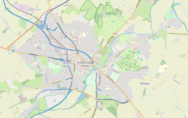
Not a bad start compared to some towns in the UK. Some of these paths are better or more heavily used than others, but they're all already there which is good. But even so there are obvious missing links and isolated sections that should be joined up. We could also do with off road links to some of the nearby villages such as Tiddington, Alveston and Clifford Chanbers. South east of the river has very few off road cycle paths, and there is a pressing need for at least one, or maybe two crossing points over the Avon (over Seven Meadows Road bridge to the south and something at/near the Tramway/Clopton bridge in the town centre).
So I created another new layer in the Gimp, and drew on, in red, potential places for additional off road segregated cycle infrastructure that I thought might be useful:
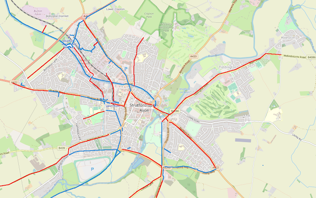
Now I know that some of these are (hopefully) coming. For example WCC are in the final throes of designing a full off road cycle route alongside the A422 Alcester Road, linking up the fragmented bits that are already there. The Birmingham Road route is also being refreshed/upgraded at the moment and the new housing developments along Bishopton Road seem to include off road mixed use paths in the plans.
I also didn't put a route in through Wood Street/Bridge Street in the town centre because I thought that might be better pedestrianised (with decent cycle parking for shoppers!) and have the "thru route" for cyclists go round the Birmingham Road. As with everything to do with Stratford's town centre, that might be a controversial idea.
I then wondered what order I'd do the not-yet-planned ones in if someone made me active travel transport planner for the district, and gave me a bag of dosh? Here's my initial thoughts in order of priority:
- Tiddington Road, including a new cycle bridge over the Avon. Probably the most expensive option first, as its long and the bridge will no doubt be a couple of million quid alone. However the space is there, the Tiddington Road is often busy/congested and there's a good population in Tiddington/Alveston that could make use of it. Indeed the existing wide footpaths are often already used by cyclists (illegally), so the demand appears to be there as well. It would also give a decent cycle route to the YMCA Youth Hostel in Alveston and the holiday home/camping/caravan sites along the road to Tiddington (tourist support!). On a purely personal level, it would also be great to get to my allotment safely by bike!
- Joining onto option 1, off road cycle path from the bridge across the gyratory and then up the Birmingham Road, to join the segregated route already there. I'd include a spur from this along Arden Street/A4390 to link Birmingham Road with Alcester Road to both avoid the town centre and also pass by the entrance to Stratford Hospital.
- Next a small, hopefully cheaper one, but again on the Birmingham Road. Link the end of existing off road cycle route alongside the Birmingham Road to the cycle path alongside Bishopton Lane. Why this gap is still here I don't know. Providing it would give a more direct link from Parkway Station and the P&R to the Birmingham Road route, as currently you have to know the "secret" cycle path through the housing estates. It would also improve the network usability of the existing mostly off-road route from Snitterfield to the Bishopton Lane roundabout (which is there but hardly anyone seems to know about, use or maintain).
- Banbury Road. Oodles of space. Busy road. Obvious place to link the Trinity Way cycle path to the town centre and provide a better active travel route from Trinity Meads.
- Another small one, but annoying: a foot/cycle link to the recycling centre at Burton Farm. Pedestrians and cyclists are currently banned from using the recycling centre because of the traffic light controlled railway underbridge entrance to the site. On the map I draw a line from the canal tow path to the site as an alternative. Obviously land ownership issues, but maybe something could be worked out? Providing active transport options to access these council services provided to local residents would seem a no brainer if the councils are serious about climate change.
- A link along the Seven Meadow Road over the Avon. I was once told that a cycle route was proposed when the road was built (on the old S&MJR railway line - it reuses the base pillars of the old railway bridge over the Avon) but got canned before the road was built. A shame as it would link up the Greenway (popular leisure area) with the town centre and Trinity Meads. Also would give me a nice route to cycle to Waitrose (I'll have to stick to Morrisons on my side of town until then!).
- Mason Road/Timothys Bridge Road. Bit of an odd one as there are cycle paths at either end, and the tow path cycle route in the middle but not much in between. Coming from the Bishopton Lane end of Timothy's Bridge Road its not even really clear where the off road cycle route ends... it just sort of fizzles out of existence (wide path at first just like the Bishopton Lane mixed use section, but then the kerbs aren't dropped and path narrows). This is an industrial/employment zone in the town, and thus it would be good to get more people cycling to/from work. In fact just a little way up Mason Road from the Timothy's Bridge Road junction there's Pashley Cycles factory... I bet they have the odd cycle user work there.
- Clopton Road. Quite busy, existing wide pavements in many places, links lots of housing to the north of the town with the town centre. Also has Thomas Jolyffe primary school on the route, so it might encourage more cycling to/from school.
- From Stratford-upon-Avon town railway station over the disused railway bridge. This comes up every so often, usually in relation to canal quarter plans or redevelopment of the railway lands. Seems to be a number of options of where it could go at the far end, but a cheeky one I've not seen mentioned would be to switch back round in to land between the disused bridge and the active railway bridge to join the canal towpath. The towpath is already a nicely surfaced cycle route that links to the Birmingham Road. This would result in a path going to/from the station to Birmingham Road/Maybird shopping area which avoids the car oriented Western Road.
- Turn one of the footpaths through Shottery Fields into a mixed use path, to give a link between the town centre and Shottery for cyclists. Would also potentially link up several schools/colleges. Biggest issue would appear to be the limited width of the existing path around the paddock/allotments to get to the track that leads to the Shottery.
- A route to Clifford Chanbers from the Waitrose roundabout, linking into the other routes along Trinity Way, the Tramway and Seven Meadow Road. The Clifford Chambers road is often quite busy and that roundabout can be a nightmare to get round/over.
- Resurrect more of the old Tramway route out towards Shipston/Newbold. This already has a project team working on it!
- Evesham Road out towards Luddington. In fact I was half tempted to not include the Evesham Road section at all, as it already has painted cycle gutters and there's the much better parallel mixed use path along the old SM&JR railway track behind the racecourse. This latter path may well then link up with the planned long distance route proposed by the Arrow and Avon Greenway Project.